We woke on Day 6 to a wet, rainy day. Undeterred, we got on our way to tour the Snaefellsnes Peninsula. The geography of the Snaefellsnes Peninsula is dominated by the Snaefellsjokull glacier of literary fame (read on for more details). I believe on a clear day you'd see the peak of the glacier, but it wasn't happening today. The light wasn't as perfect for photography, but we still got some fun shots. We passed through the small fishing towns of Olafsvik and Rif.
 |
| Makes you wonder, doesn't it. |
 |
| The long winding road |
 |
| All of a sudden, things got dark... |
 |
| But the clouds soon passed ... and here's another quirky church at Olafsvik. |
We stopped for a stretch at a little fisherman's museum in Rif. We weren't feeling up to touring a museum, but poked around for a bit.
 |
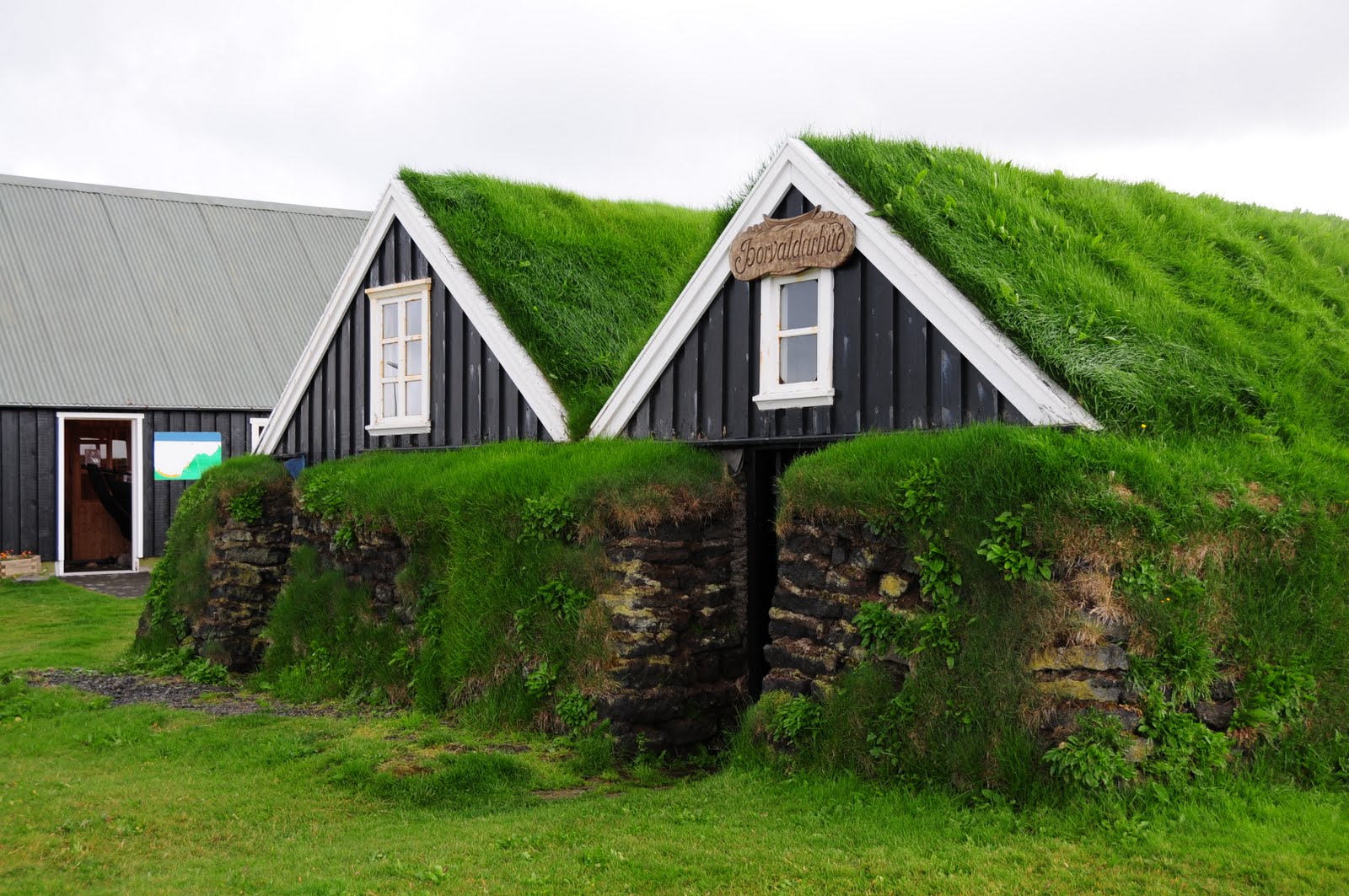
Turf houses at the Fisherman's museum in Rif.
Photo Credit: Sharon Chan |
 |
Statue at the Museum. Fishing is a way of life for many in this part of Iceland.
Photo Credit: CT Goh |
We made our way to the Ingjaldsholl church, which claims to be the oldest concrete church in Iceland, and possibly in the world. There has been a church of some form standing at that site from at least the year 1211.
 |
| The church stands out in the dramatic landscape |
 |
The church up close
Photo Credit: CT Goh |
 |
| A view of the interior through the window. The doors were shut, so we couldn't get in. |
 |
| The flora around the church |
Church visit over, it was time to hit the bird cliffs on the Southern end of the Peninsula. First was this bright yellow lighthouse at Saxholsbjarg, overlooking some dramatic cliffs.
 |
| Apparently, in the summer months, the locals would lower themselves down these cliffs to harvest eggs and sometimes the birds for food. |
 |
| Bird on cliff... and yes, that's what the white stuff is. |
 |
| We often felt dwarfed by the landscape |
 |
| More birds on cliffs |
 |
Moss and/or lichen (?) on the cliffside made the whole place an explosion of colors.
Photo Credit: Sharon Chan |
Not too far from here was a popular tourist stop - the Lifting Stones at Dritvik. These are four stones lying on the beach which were apparently used to test the strength of wannabe sailors. The largest, called
Fullsterkur or "full strength" weighs 154 kg; the second,
Halfsterkur or "half strength"100 kg; third was
Halfdraettingur or "Half Carrier" at 54kg; and finally Amlodi "Hamlet" or "Weakling" at 23 kg. To qualify as a sailor, one needed to be able to lift at least
Halfdraettingur. Surely, you didn't expect them to hire a weakling!
 |
| Considering the odds... |
In the end, I believe CT just made it to be a non-weakling. Sharon was decidedly a weakling, at least by sailor standards. Considering that even the smallest stone was.. um.. a significant portion of my actual body weight, I was happy to concede that the life of a sailor was not for me.
Behind the lifting stones, there was a lovely black pebble beach, where we found the remains of the Epine Trawler shipwreck and looked out on to the crashing waves.
 |
| The remains of the British Trawler, the Epine GY 7, which was wrecked just East of Dritvik in March 1948. |
 |
| The choppy sea that day |
 |
Glistening wet pebbles
|
It was more bird-cliff hunting for us after that, this time at Arnastapi. It was a little too wet for us to go that far ... but just far enough for me to get some great raindrop macro shots, which made me very happy.


 |
| The rocky birdcliffs of Arnastapi |
 |
| Here's a game -- can you spot CT? |
 |
| I thought this was just beautiful |
 |
| Photo Credit: CT Goh |
 |
The birds
Photo Credit: Sharon Chan |
 |
The vastness of it all, and the strangeness
Photo Credit: CT Goh |
At the start/end point of our hiking path was this huge statue of Bardur Snaefellsas, the deity of Mt. Snaefell, produced in 1985 by Ragnar Kjartansson. Apparently, Bardur was descended from both giants and men, son of a King in Northern Hellaland in Scandinavia. He staked claim to the land of Laugabrekka by the glaicer at the end of the 9th century. He did not die, but disappeared into the Snaefell Glacier, becoming a nature spirit to whom the locals offered petitions.
 |
Bardur Snaefell, Deity of Mt. Snaefell
Photo Credit: Sharon Chan |
We worked up a nice appetite after this 1.5 hour hike along the wet, sodden birdcliffs, so it was time for lunch, and boy, we picked an interesting spot!
 |
| Our charming little lunch spot |
We were first drawn by the fact that there were more cars than usual in this spot. Given how few other tourists we had seen, we were intrigued. Was this a roadside stop for bus tours? Was there particularly good lunch here? Then we looked a little to the left and saw this:
In the Jules Verne book
Voyage to the Center of the Earth, the cave leading to the center of the earth was found here, at the foot of the Snaefells Glacier. The signage speaks for itself:
 |
| Photo Credit: Sharon Chan |
 |
| Photo Credit: Sharon Chan |
 |
| In the story, the adventurers turned up in Stromboli, 2434 km away from this spot. |
For many travellers, I think Jules Verne's tales fanned the wanderlust, itching for adventures in foreign lands, so it was apt to have run into Verne's universe here in Iceland. As for the restaurant, we were glad for a warm dry place that served half-decent food. It wasn't revelatory, but at least it was warm and tasty.
Re-fueled, we moved on to see our last waterfalls of the trip - Hraunfossar and Barnafoss. Hraunfossar is essentially a stretch of mini-waterfalls falling over a 1 km stretch. Coupled with the sprinkling of flowers throughout the entire area, it made for very pretty scenery.
 |
| Hraunfossar |
 |
| Hraunfossar from a distance |
Barnafoss was the exact opposite. It was a churning, fierce waterfall with a tragic past. Barnafoss or "Children's waterfall", was named after two children fell off a stone arch spanning the river and drowned. Their mother had the arch destroyed to prevent the tragedy from happening again.
 |
| The churning waters of Barnafoss |
 |
| Photo Credit: Sharon Chan |
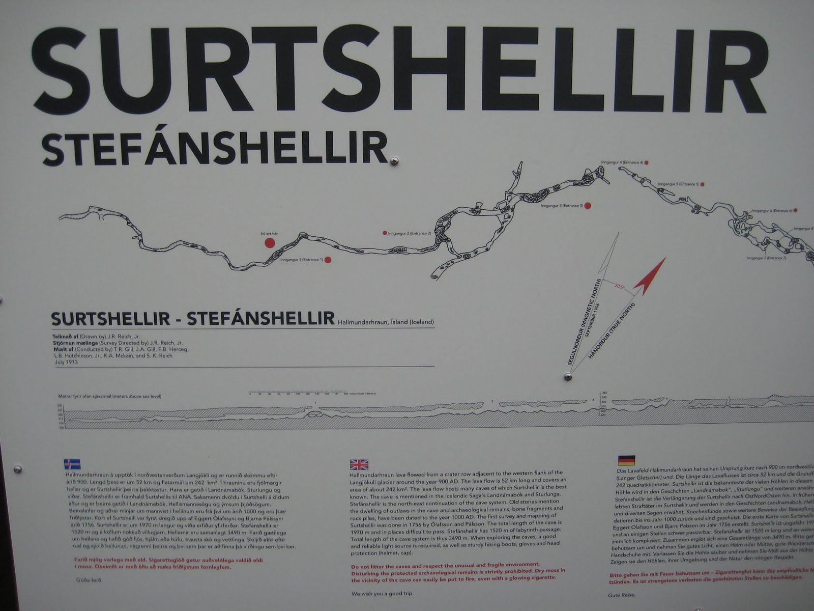
Our next and last stop before Reykjavik was the largest lava cave in Iceland, Surtshellir. The rocky, 1.5 km long cave was bigger than we had ever expected, and our initial intentions to explore even a tiny section of the cave were quickly abandoned.
 |
| One of four cave openings in this area |
These caves are mentioned in Iceland's historic sagas as places where outlaws used to live in hiding. Bone fragments and evidence of ancient human habitation have been found in these caves, dating back to 1000 AD.
 |
This was about as far as we dared to get into the cave. It was very very dark, and very very creepy beyond this point.
Photo Credit: CT Goh |
 |
Another cave opening
Photo Credit: Sharon Chan |
 |
That is the look of fear and defeat.
Photo Credit: CT Goh |
Anyone considering an adventure in these caves had better pack solid hiking shoes, super-bright spelunking helmut-lights, and a lot of guts. Serious cavers only.
 |
The signboard showing the expanse of the cave
Photo Credit: CT Goh |
With the fog rolling in, and the light going away, Surtshellir got considerably scarier... and we drove away towards the bright lights of Reykjavik, Iceland's capital - and biggest - city. There will be more on our exploration of Reykjavik in the post on Day 7 (our last full day in Iceland) but here's one photo I managed to get of the iconic chuch Hallgrimskirkja lit up that night.
 |
| At 74.5 meters tall, Hallgrimskirkja is the tallest structure in Iceland. |


Hi, I really enjoyed reading your photoblog. I'm planning a trip to Iceland for September and will take a few of your tips! Thanks for sharing the photos and experiences.
ReplyDeleteCheers,
Randall
Lovely photos!
ReplyDelete